
With regard to the mountains, on a clear day you can sit on the top of Mt. Cuyamaca and (with the help of a pair of binoculars) looking west, you can see all the way to the airport. The airport, incidentally, sits at sea level.
Thus, concering the distance from the beaches to the mountains: San Diego County slopes east to west.
 |
| Beaches to the left (west); mountains to the right (east). Incidentally, the flags indicate black bear sightings up through the year 2000 (glad I didn't know that before planning my camping trip!) (c) San Diego Natural History Museum |
If you ride due east for a significant distance in San Diego County you are going to climb. If you ride due west for a significant distance you are going to coast (in general). Thus, our basic rules for riding significant distances in San Diego are:
- it's relatively easy to ride east to west
- it's more difficult to ride west to east
Conversely, if you camp in the mountains - it doesn't matter if it's the Cuyamacas or the Lagunas - you can easily pedal home to the city in a few hours.
As an example, just last week I planned to camp at Green Valley. Rather than attempt to pedal from National City to the Cuyamacas while loaded with camping gear - a good way to develop a hernia, I assure you - I first camped at Lake Jenning in roughly the center of the county and then the next day pedaled further east to the mountains. Even that abbreviated second-day trip was a slog; it was almost entirely uphill.
The following day when going home I contended with snow, rain, and mud, and yet still I was home safe and sound that afternoon (it would have been sooner but stupid me made a wrong turn in Rancho San Diego and killed some time and energy), a distance of some 50 miles.
50 miles in one day while loaded down with camping gear on a bicycle? Not a problem when you're riding east to west.
This little essay begs the question: what about riding north to south or south to north?
North to south:
Along the coast: I've ridden from Oceanside south to National City using coast routes and this is a pretty easy, breezy ride that spans most of the San Diego County coastline. The only real climb is the Torrey Pines grade and that's not a difficult climb. I've done it with full camping gear and didn't have any problems.
 |
| Early photo of Torrey Pines grade. Photo (c) Google. |
From UCSD south to downtown it's mostly downhill. A very fun ride; a great way to spend a Saturday morning.
If you prefer to detour into La Jolla and work your way down the city beaches, this again doesn't involve any real difficulty. In that instance I like including in my ride the cliff walk overlooking La Jolla Cove and later the Fay Ave. bike path.
 |
| La Jolla Cliff Walk. Photo (c) Google. |
Inland: There are a couple of significant grades that come to mind.
I don't especially care for Pomerado Road from Scripps Poway Parkway up to the intersection with ... Pomerado Road, again! (A little confusing: Pomerado "t"'s into itself). I don't care for it because it's steep, that area is usually very hot and dry, and there's nothing at the top of the hill other than homes. No markets, no place to sit on a bench and enjoy the breeze from the top of the hill, nowhere to buy a bottle of water.
 | |
| At this intersection Pomerado Rd. "t"'s into itself. Reason? |
Then there is Mission Valley. This is at about the three quarters mark toward the south of the county, bisecting San Diego County on a east-west axis. The Interstate 8 goes through Mission Valley.
The Valley extends from close to the coast to probably La Mesa to the east. If you travel inland for a significant distance you will have to contend with it.
In San Diego city you will wind up climbing out of Mission Valley whether going north or south and the climbs are rather steep. During my work commute I climb Bachman Pl. going south and Ulric St. going north. As you go further east, you might have to climb Texas St. going south and Mission Village Dr. going north. Another combination of climbs is Mission Gorge Rd. and Fairmont. Or College Ave., which runs both north and south out of the Valley.
None of these are fun climbs but they are certainly doable... even by relatively inexperienced riders. They're just a major pain the ass.
You can bypass the Mission Valley climbs by coasting downhill into the Valley and then simply riding west to Mission Bay and proceeding either north or south from there.
Mountains: the terrain seems to incline toward the north.
Edit: riding north to south on the Sunrise Highway is not an easy ride. If you are hauling camping gear it is a hard ride. Be aware of this before planning such a trip.
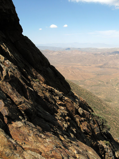 |
| Kwimee Point in the Laguna Mountains provides a beautiful view of the desert. Photo (c) Google. |
South to north:
Along the coast: you'll climb from the Rose Creek path up to UCSD and Torrey Pines... but this isn't especially difficult. The hills involved are incidental; they don't describe a general trend in the terrain.
If instead you work your way up the city beaches to La Jolla, you'll have to somehow get up to UCSD. This can be a slog! Much easier to first go to Mission Bay and then use the Rose Creek path.
Inland: (say from Spring Valley to Escondido) I haven't noticed any real change in terrain that would require any special preparation although, as mentioned above, do be prepared to climb out of Mission Valley. San Diego County inland gets quite hot and dry in the summer so bring plenty of water.
The exception is if you continue past Escondido to Valley Center and then, say, to Palomar Mountain. I've never ridden this route but my understanding is that around Lake Wohlford it gets steep. This ride - in my estimation - will involve some difficulty. Bring lots of water!
Mountains: the terrain seems to incline toward the north. Riding from the south will be a slog. Best to plan your trip west to east to an upper point... say the Wm. Heise campground in Julian... and proceed from there south into the Cuyamacas or the Lagunas.

No comments:
Post a Comment